Enregistrez gratuitement cette image
en 800 pixels pour usage maquette
(click droit, Enregistrer l'image sous...)
|
|
Réf : T01523
Thème :
Terre vue de l'espace - Iles - Récifs (286 images)
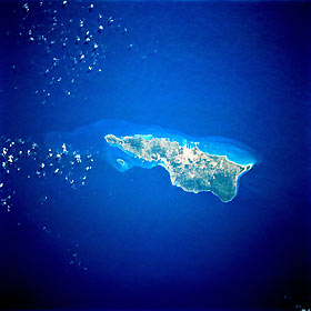
Titre : Saint Croix, Virgin Islands of the United States January 1993
Description : (La description de cette image n'existe qu'en anglais)
Saint Croix, largest of the Virgin Islands, is visible in this near-vertical photograph. Saint Croix, covering 80 square miles (more than 200 square kilometers), is of volcanic origin and is characterized by rugged slopes that rise abruptly from the sea. Most of the rugged hills are on the north and northwest sides of the island (dark green area), with the highest elevation approximately 1170 feet (350 meters) above sea level. The island of Saint Croix was discovered in 1493 by Christopher Columbus. The major city of Christiansted is located near the center of the northern coast. Large pasturelands are visible along the southwest coast. Tourism is the island’s major industry; the petroleum processing and chemical industries are also important in the island’s economy.
|
|

